Fresno Fly Fishers For Conservation
Sixty Five Years and Counting...
| | Fly Dope Volume 65 Issue 06 | | | Editor's Note:
Welcome to the June 2026 FFFC Newsletter!
Please Note:
Downloadable files of the newsletter will be available in our club's Document Library within a few days of the newsletter's release. Here is a link: Fly Dope Newsletters
Tight Lines!
Mark
|  |  |
June 2026
Most Amazing FFFC Members,
We couldn't have been happier with this year's Youth Academy. Fourteen engaged young men and young women learned to tie flies, cast, tie knots, understand gear, and then fly fish for bluegill and bass. One young woman, as she caught her first fish, yelled, "I did it! I did it!" What a wonderful event the FFFC organizes each year to help a new generation and their parents or guardians develop a love for this sport. By the end of the day, everyone caught fish, and each participant left with a brand new Crosswater rod and reel combo, zinger, forceps, leader, tippet, and a box of handtied flies provided by board and FFFC members. As the same young woman noted, it was "EPIC!" Thank you to all those who participated and made this event successful, whether in person or through financial contribution. You make a difference!
We're looking forward to our June meeting. Rachel Sapper, Lucy Stiff, and Cali Trainor are Climate Action Corps fellows with the California Department of Fish and Wildlife Inland Fisheries Unit. I met them while helping with the annual electrofishing on the Kings River. At the San Joaquin Hatchery and Salmon Conservation and Research Facility, they work with a variety of salmonids and serve as stewards of the Friant Interactive Nature Site through urban greening and wildfire resiliency initiatives. Their job duties include spawning and rearing fish, conducting river surveys, running aquatic education programs, and leading volunteer events. They look forward to speaking with the Fresno Fly Fishers about their careers and how the Inland Fisheries Unit works to keep recreational fishing accessible and sustainable. They will cover the climate, its impact on aquatic systems, and how to integrate conservation and stewardship into your daily life.
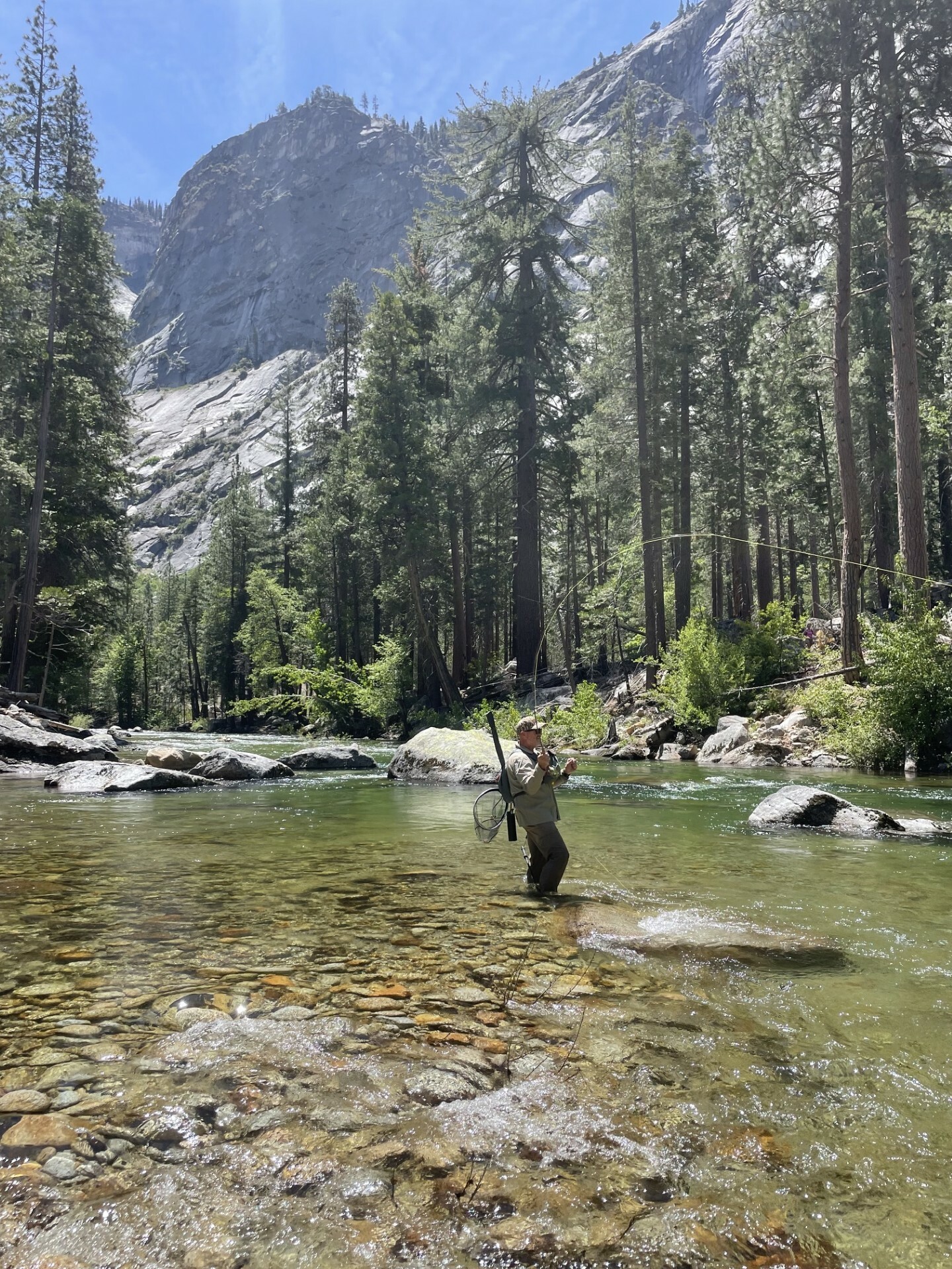
Regarding fly fishing, while the flows are still a bit high, I hiked the South Fork of the Kings with my friend and Kings River fly guide Scott MacDonald, fly fishing sections I hadn't fished before. It was far more of an obstacle course than we expected. There were hundreds of downed trees, some wider than I am tall that we had to climb over. And then there were areas so overgrown we had to bushwhack our way through. And I wish I didn't have to mention the tick my wife found that I brought home! By the end of our day, we both decided we wouldn't do this adventure again. How was the fishing? The day was challenging, the water was frigid, and we netted well into the double digits, catching far more Browns than expected. Fun, beautiful, but tough fishing! We are fortunate to live so close to such beautiful water.
Don't forget our outing on June 27th at Marble Fork. This is a great section for catching small fish on a dry fly. See our website for more information. We'll see you there!
President
| Thursday June 4th 7:00 - 9:00 PM
Provost & Pritchard Office Building
Topic: Climate Action Corps - How to Integrate
Stewardship in your Daily Life
Presented By Rachel Sapper, Lucy Stiff, Cali Trainor | 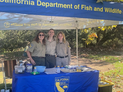 |
Rachel Sapper, Lucy Stiff, and Cali Trainor are Climate Action Corps fellows with the California Department of Fish and Wildlife Inland Fisheries Unit. They work with a variety of salmonids at the San Joaquin Hatchery and Salmon Conservation and Research Facility, in addition to serving as stewards of the Friant Interactive Nature Site through urban greening and wildfire resiliency initiatives. Their job duties include spawning and rearing fish, conducting river surveys, running aquatic education programs, and leading volunteer events.
They look forward to speaking with the Fresno Fly Fishers about their careers and how the Inland Fisheries Unit works to keep recreational fishing accessible and sustainable. They will cover the climate, its impact on aquatic systems, and how to integrate conservation and stewardship into your daily lives.
See You At The Meeting!
| Congratulations 2026 Youth Academy Graduates! | Working hard in the classroom.... | Time to get outside and practice our casting....
| |
Marble Fork of the Kaweah June 27, 2026
The Marble Fork of the Kaweah River near Lodgepole in Sequoia National Park has proven to be a great spring fishery in recent years. Depending on conditions, we have see great dry fly, as well as nymphing success. This is a beautiful area and a great place to gather as a club and enjoy a day of fishing together.
Kern River Heritage Trout Challenge July 23-25
There are three of the Heritage Trout species in the Kern River Basin and Golden Trout Wilderness area. The Little Kern Golden west of the Kern River, the Kern River Rainbow in both branches of the Kern River and the California Golden Trout on the east side. We are planning a 3-4 day trip to pursue each of these three species. Stay tuned for more details.
Go Here to see our full Event Calendar and to register for events
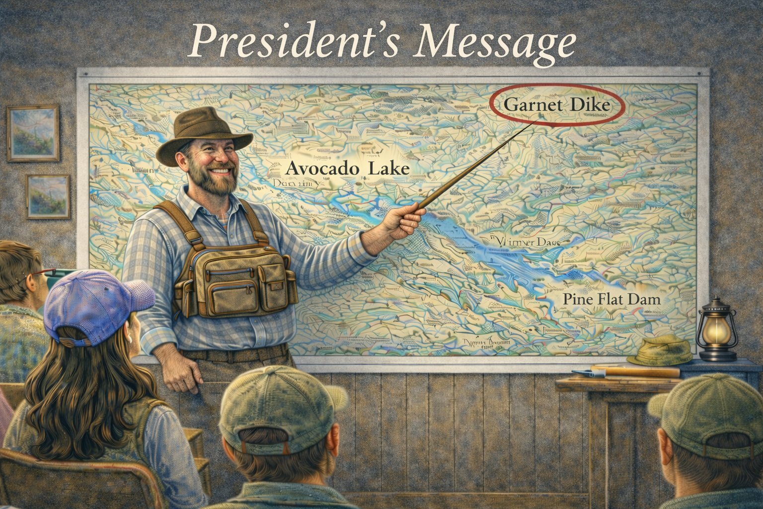
| | Nymphing is about to Get More Expensive | | If anyone needed an excuse to fish more dry flies besides the thrill of watching the fish take your fly on the surface, I have one. Tungsten prices have risen 3-4 times from what they were only a year ago. It’s typically tungsten beads that are used to get nymphs down to the fish more quickly. The reason for the price jump is geopolitical in nature. Surprise, surprise, it’s China holding the cards. 80% of the world's tungsten is supplied by China. | | | The United States had its last tungsten mine shut down in 2015. Here’s an interesting fact: there is an abandoned tungsten mine above the Kings River near Garnet Dike.
There is a high global demand for tungsten. This dense metal is used in all kinds of businesses: the defense industry, and in the production of semi-conductors and solar panels. In our niche sport tungsten is used to make beads, coneheads, and even in the manufacture of sinking lines. In 2025 the Chinese government implemented strict controls over where, how much, and to which countries tungsten would be exported. | |
All is not lost. Curtis Frye, co-owner of Fly Fish Food, explains that we the consumer may not feel the pain in our wallets immediately. Fly shops have inventory of tungsten products on their shelves that were purchased wholesale prior to the latest price increases. Higher prices will be reflected when shop owners have to restock and buy product at a higher cost. Stock up on beads now. Curtis does a great job in his latest video explaining in greater detail what I have outlined above.
| | | |
There are cheaper end arounds for avoiding high priced tungsten. Brass beads are cheap and readily available. Though not as dense and efficient as tungsten in getting your flies to depth, they do work. Split shot crimped to your tippet or lead wire wrapped on your hook shank are tried and true methods for getting nymphs into the zone. With high end fly rods costing north of 1,000 dollars, we need to put the higher cost a fly will cost us in perspective. Inflation is not going away anytime soon.
| Back of Beyond Stephen Neal
In Wildness is the Preservation of the World - “Henry David Thoreau."
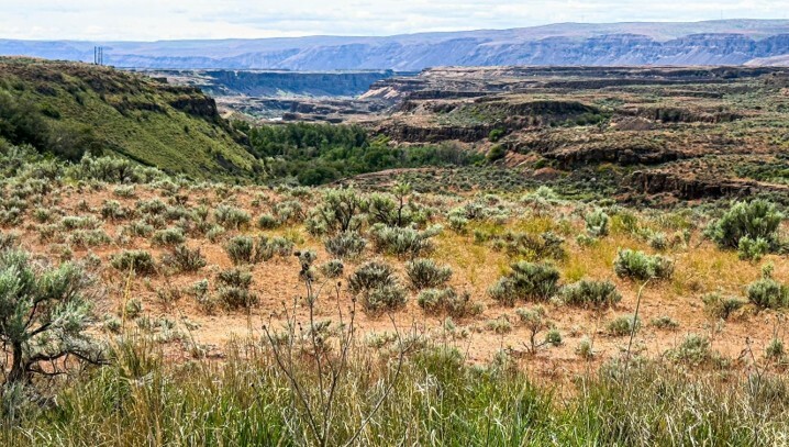
| Channel Scablands
The sound reaches you first, faint, but its low rumble soon becomes a roar. As it continues to increase the volume is soon deafening. It freezes you; what do you do with this sound? It has not been heard before. Do you flee, if so, in what direction? Little do you know that you were doomed before you even heard the sound! As the sound hits its crescendo you are blasted by a mass of compressed air that has been propelled by a 500-foot wall of water mere feet away and moving at just under 60 miles per hour. How much force is in the blast wave? Think Mount Saint Helens’ 1980 volcanic eruption force. Everything around you is instantly flattened. Trees bend back and collapse too fast for your eyes to capture the motion. We are tempted to compare this blast with that of Mt. Saint Helens in 1980, but that eruption was paltry compared to the devastation of the Missoula Floods eighteen thousand years ago. | 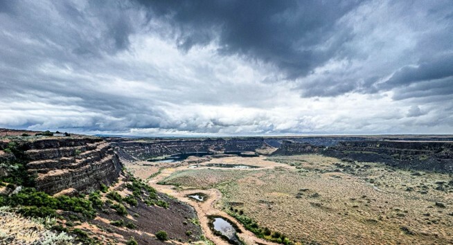 | | Dry Falls in the Grand Coulee. Western drought has shrunk the lake at the base of Dry Falls. The wall of water coming over the top of the escarpment would have been 200 feet tall while moving at 58 mph. That 200-foot wall of water would stretch across the horizon as far as your eyes could see. | Our brains comprehend the universe, based upon minute particles from an infinitesimal sampling pool. Our brain’s database entry system gathers information from sight, touch, sound, and smell. From this tiny database, we create a world view. Considering how small we are in comparison to our Planet Earth, let alone our stature in the cosmos, it is little wonder that we have difficulty comprehending geological time and catastrophic events that are 237 lifetimes in our rearview mirror (based upon an average 76-year life span).
This is the story of a cataclysmic earth event and of some of the men who unravel its mystery. From clues they found, they put together the story of the Washington Scablands, Glacial Lake Missoula, and the mega-floods that rocked the accepted geological world to its foundation.
The geological event was identified by J Harlan Bretz. He spent four years teaching high school biology and spending his summers mapping glaciers that formed Puget Sound. He then returned to college to earn a geology degree. As a professor of geology in Chicago he returned with some of his students each summer to Eastern Washington to map and document his belief that the Channel Scablands of Eastern Washington were created almost overnight by a catastrophic flood. He named the flood plain “The Channel Scablands” and the flood itself the "Spokane Flood". | 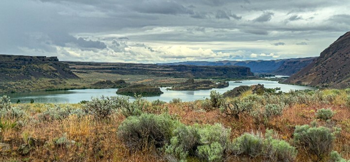 | | Lower Grand Coulee just below Dry Falls, looking down canyon at Blue Lake from Dry Falls/Sun Lakes State Park
| This field work was done before the advent of aerial mapping. With his students he hiked the land and created their story of the mega-flood from clues which, due to their immense size, hid themselves. Today we are able to see aerial images that allow us to easily identify large water ripple marks, channels, and kolks (pot holes) that form beneath flowing water. Bretz was able to piece together the story from observations of normal rivers and streams and make the connection to what he was seeing wrought upon the land by a flood of unimageable size. Bretz had found evidence of the flood but was unable to locate its water source. Much later Joseph T. Pardee found the water source, Glacial Lake Missoula.
Pardee, a native Montanan, grew up in a mining town. He attended U.C. Berkley from 1889 to 1891, studying chemistry and mining. He then moved back to Montana and opened an assay office. He then sold the assay office, farmed, and operated a placer mine while studying geology books. Pardee passed the civil service exam in 1908 and went to work for the U.S. Geological Service in 1909. His first assignment as a geologist was to investigate Glacial Lake Missoula. In his fieldwork he traced the ancient glacial lake and followed traces of its shoreline down the Clark Fork River to the panhandle of northern Idaho, where it eventually disappeared. Here he found the site of the now vanished ice dam that had once held back the continental ice sheet melt-water that had filled Glacial Lake Missoula. In 1910 he presented his findings on Glacial Lake Missoula.
Doing the leg work and backing his findings with recorded data didn’t guarantee acceptance, however. It took over forty years for the Geological Society to finally acknowledge that Bretz’s field work was correct; his predicted catastrophic events had happen. Gradual erosion was not the primary driver of geological changes. His major detractors were eventually convinced once they visited the “Channel Scablands”. Indeed, many of his colleagues began to call them “Bretz’s Floods” in his honor. Today, however, they are commonly called ”The Missoula Floods.”
Eighteen-thousand years in the past, the last ice age was ending. Not an abrupt ending, but one that would take over three-thousand years (39.5 lifetimes). The ice sheets lying over Canada continued to wax and wane, creeping down into the northern parts of what is now the United States. During these gradual warming a huge lake formed over present-day western Montana. The lake formed behind an ice dam (a lobe of the continental ice sheet), 30 miles across and nearly half a mile tall. It contained 50 cubic miles of ice with embedded car sized rocks. That bears repeating; 50 cubic miles of ice! | | Picture that if you can, but it’s extremely hard. It’s 2.8 Mount Rainiers. Good luck finding a Scotch glass large enough to hold even one cubic piece of that ice. It gives new meaning to “I’ll take mine on the rocks.” The glacially formed ice dam carried with it ice-encased rocks from Canada. When the ice dam failed the embedded rock was eventually deposited over hundreds of miles, some in the Willamette Valley and others offshore in the Pacific Ocean over 500 and 600 miles from their origin.
Lake Missoula's surface area covered 2,900 square miles, fully 411 square miles larger than the state of Delaware. Its depth at the dam was 2,100 feet and 950 feet over Missoula. Lake Missoula held over 530 cubic miles of water and ice, half the volume of Lake Michigan. When the ice dam failed its water was moving at just under 60 mph, 9.46 cubic miles of water per hour. By comparison the largest discharge flow on the | | | butte downstream of Dry Falls. It would have been
completely underwater during the Missoula Flood.
Mississippi has been measured at 0.05 cubic miles of water per hour. Researchers have calculated that the flow from Lake Missoula was 10 times the combined flow rate of all the rivers on earth. If this was a movie, foreboding music would swell, causing chills to run up your spine.
The released water overwhelmed the existing channels, seeking the quickest way to the Pacific. New channels were cut and extensive braiding occurred. The water in many places was over 400 feet tall, even taller where it met hydrological constrictions. There were no falls or cataracts as we know them. All the scouring and plucking of basalt happened beneath the water’s surface. What is now called Dry Falls is located in the middle of the Grand Coulee. The falls have moved upstream 15 miles from their original location; this happened during at least 40 recorded flood events.
The pertinent point here is that all that upstream movement happened underwater. The water was 200 feet deep when it flowed over this 350 feet tall and 15-mile-long escarpment, (5 times the width of Niagara Falls). The flow of the water was so deep that it would appear as a sharp incline rather than a waterfall. That view would have given you no clue as to what was happening below the surface. The forces under fast, deep-flowing water create underwater tornadoes, vertical vortices strong enough
| | to lift rocks heavier than trucks and carry them away, and more destructive than tornadoes tossing mobile homes around. Dutch and German hydraulic engineers call them “kolks”. Geologists use the name to correctly identify the pot hole lakes. These are kolk lakes, created by underwater tornadoes. Kolks are found all along the route the floods took on their journey to the Pacific. They are a gift to fishermen. They dot the landscape and most hold fish. Lake Lenice is a kolk lake left by the Missoula Flood, it has blessed my friends and I with a fish or two, and its songbird population puts on a first-rate concert, a great backing track for our fishing experience. Wine drinkers should also rejoice; Washington Vineyards are now grown on the soil that the Missoula floods deposited.
The first flood was the largest. In the next 3,000 years that it took for the ice age to end. The ice caps continued to cycle while moving further | | | Basalt outcropping on butte on the floor of Dry Falls
south, swallowing rocks and creating new ice dams, damming rivers, and recreating massive lakes. In warm periods the ice sheet would retreat. The ensuing water runoff would swell the lakes even further, creating stronger forces on weak structures. This caused them to fail, to the point of failure, thus releasing a new Missoula Flood, that continued to change the landscape of 4 states. These mega-floods happened at least 40 documented times and possibly up to 90. Sixteen thousand square miles (Maryland and Connecticut combined) of Planet Earth were catastrophically altered by water. A beautiful self portrait by water.
Lake Missoula drained in less than three days; it also caused the drainage of Lake Columbia, a second glacial lake just below Lake Missoula’s ice dam. These waters overwhelmed the existing river and stream system, gouging out the old and creating new. Where the deluge met resistance, it went around, over, or through.
In spite of popular belief, the Columbia River never flowed through Grand Coulee or over Dry Falls. The Columbia River channel lies lower in elevation than Grand Coulee. So, while the floodwaters filled the Columbia River the waters were so high that they overtopped a ridge line and created a new path to the lower Columbia, leaving Grand Coulee in its wake.
I recently visited Dry Falls after a nearby fishing trip. As I drove down the Okanogan River Valley results of this ancient flooding were obvious on the hills, with many hanging valleys in evidence. From the junction of the Okanogan and the Columbia rivers I drove to Grand Coulee Dam. The distance (41 miles) represents just the northern edge of the Missoula Floodplain. Erratics and kolks are strewn across the landscape. I was in awe; the land is well above the Columbia River yet during the flood was under 200 feet of water. I cannot impress upon you enough just how large the Missoula Flood was.
|  | | Outside Coulee City, Washington, south and above Dry Falls. The flood waters here have eroded the landscape to rejoin the water flowing through the Grand Coulee over the escarpment. | At restriction points like Wallula Gap, (1.2 miles wide) the waters backed up. This gap restricted the flow of the flood water, allowing only 1/5th of the water through. As a result, the climbed to 1,247 feet while it also backed up the Snake River. Below the Wallula Gap, the Columbia River channel is constrained by tall canyon walls which slowed the floods flow. This resulted in the John Day and Deschutes River backing upstream hundreds of miles. As it rose it began overtopping its constraining canyon walls and found new-ways to reach a rivers drainage system, and filling valleys. The Willamette Valley was a lake from Portland to Eugene. Virtually I-5 from Portland to Eugene was at the bottom of the lake.
Two hundred and thirty-seven lifetimes ago the world was wetter and colder than it is today. The lowlands and river valleys provided firewood, shelter, water, fish, and game. Eastern Washington and Oregon were home to herd animals of the late ice age. Wooly mammoth and mastodons, longhorn bison and camels, caribou and musk ox roamed the plains. Following these game animals came the hunters; humans, wolf packs, saber-toothed tigers. Giant condors searched for the carrion left behind. Along the feeder streams giant beavers-built dams while short-faced bears vied with early humans for the abundant salmon that swarmed up the Columbia and its side streams. Early human remains have been found predating the floods. Although no human remains have been found in the Missoula Flood Plain, we can safely assume that the land was inhabited by small, scattered | 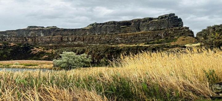 | | Bottom of Dry Falls looking up. 300 feet up is the lip of the escarpment, 200 feet above that was more water. This an underwater tornado basin. This is a kolk! | bands of hunter-gatherers. Each band held roughly 15 individuals, likely a multigenerational family group. This would have been an optimum number to lead, manage, and survive with their shared skill sets.
As the ice age ended the benefits of living in the river valleys, took a big hit when the Missoula Flood inundated the habitable land. Whether the flood came in the dark or in the light of day the outcome was the same. If you were asleep the sound of the flood’s approach would awaken you. Daylight would have provided no benefit. Your legs could not carry you fast enough or far enough to evade the sheer size of the flood. Even if you had been at the crest of the flood waters, it would gain you but a few yards in your flight before the water engulfed you. At ground zero, the atomic blast of compressed air would throw you back like a rag doll. In daylight as you flew backwards you might in those last brief seconds get a glimpse of a wall of brown water too tall to comprehend. It would be full of floating ice blocks, which contained immense boulders, car size and larger. With that image and terror in your heart you would cease to exist. Along with your existence the fish, game and the environment of shelter you depended upon for survival would also vanish. Sucked away in a maelstrom of churning madness, the water stripping the land to bare rock.
Author’s note: Besides Bretz and Pardee many other people who were instrumental in revealing the geological history of the Missoula Flood. Work continues to this day, and new discoveries will be made. I hope that my writing about the Missoula Flood motivates you to investigate further. Fact is, there is too much to cover in this short article! More than three books worth and YouTube and internet research that was prompted by my discovery of the Missoula Floods, and my short but awesome field trip. Thank you for letting me share the awesomeness of our earth.
Three books were my main sources of information for this article: “Cataclysms of the Columbia,” “Glacial Lake Missoula and the Humongous Floods.”, and Bretz’s Flood. There is also a wealth of information on YouTube and the internet. Bretz’s biggest detractors had never visited the Channel Scablands: once they did all their arguments fell away. Go outside and see for yourself.
As always, get outside and embrace our Mother Earth, as she is deserving of your attendance. Please protect her. | |
A Big Thank You, to Tennis Terrance for his editing suggestions.
“The world is out there, the journey starts the minute you leave the door, go outside and truly live.” – S. Neal
“When given the choice between being right or being kind, choose kind – Dr. Wayne W. Dyer
“Many go fishing all their lives, without knowing that it is not fish they are after” - Henry David Thoreau
| | Same kolk basin as above, but looking down 300 feet, that was one powerful underwater tornado! |
Discounts
California Fly Fisher Magazine
Use Code FLYCLUB to receive a $5 discount on a subscription.
Here are a few additional links to other information and websites you might find useful:
|  | ABOUT US
We are a Fly Fishers International affiliated club, a national organization whose goal, like ours, is to promote the wonderful sport of fly-fishing as well as protect our natural resources. We promote catch and release, education, conservation, and above all, encourage and help those who desire to learn more about all aspects of fly-fishing.
Fly Fishers for Conservation (FFFC) was organized in 1961 by a group of devoted fly fishers deeply concerned with the preservation of trout and all game fish, their environment, and the quality of fishing. Our club has maintained two goals since that time: To foster and promote the sport of angling with artificial flies. To protect, conserve and increase our angling resources.
Go Here if you would like to join our club!
Fly Fishers for Conservation is a 501(c)3 tax-exempt non-profit organization. This means you can use your contribution as a tax deduction. The club gets revenue from member-ship dues and the annual fundraiser dinner. We try to contribute to conservation issues in the area and to our youth with our Trout in the Classroom program, the No Child Left Inside program and by holding a Youth Fly-Fishing Academy annually. The club is al-ways in need of funds. Please consider donating. You may send a check to Fly Fishers for Conservation at PO Box 1192, Clovis, CA 93613. Your donations will be greatly appreciated and they will help the club fulfill its obligations.
|  | | Support received from the following.... | |